Thursday, 31 August 2017

5 Pitfalls of Basement Drainage - Ben Norman


For those wanting to extend a property in an area of prime real-estate, where land is at a premium and extensions have already gone back, front and up, they have only one course left ... down.

Basement extensions are popular to add further dimensions to valuable urban property, adding a study, reading room, music room, perhaps a playroom or bedroom.

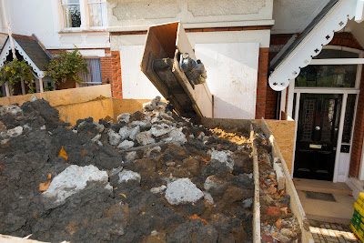
There are effectively three types of basement: converting an existing basement into a useable, ventilated, well lit and drained room(s), retrofitting a basement, excavating one below an existing property; and adding one to the plans of a new build.

We’re looking particularly at the middle option here.

Before embarking on such a retrofit basement project, please, please seek professional advice. Basement excavations do need Planning Permission, mainly relating to the installation of a means of escape or light wells as these affect the exterior appearance of the property.

As well as the obvious considerations: access, party walls, existing infrastructure etc, two major considerations are waterproofing and drainage.

 In assessing the viability of the project, consideration must be made for the following:

  • Accessibility and affects on neighbouring properties.
  • Geology, topography and the water table.
  • The proposed use of the basement.
  • Access from existing the property.
  • Ventilation and light.
  • Existing drainage.

There are different ways to make basements dry which is one of the most critical aspects of a successful basement. The waterproofing falls into 2 main areas, cementitious tanking and cavity drain membranes.

Tanking, layers waterproof material directly to basement walls, ceiling and floor, encapsulating the space in a waterproof ceil. A cementitious waterproof render system is applied in several layers, linked to a waterproof screed on the floor.

Alternatively membranes are used to create an inner waterproof structure with a cavity (created by the membranes studded profile) behind it that is fully drained. The constant draining reduces any pressure build up on the exterior structure.


The pitfalls:

1. Failure to check the location of existing drainage and services - Quite often existing sewers run across the rear of properties, particularly terrace housing.  Typically these sewers are around 1.5m deep, just about head height in the proposed basement.

2. Following on from number 1, owners naturally want to maximise basement space and extend right up to the plot boundary. This offers a bigger new 'family room' but leaves no space to divert the sewer. Manholes and drainage would now have to be located outside the plot boundary, perhaps even on neighbouring land.

3. Following on from 2 regarding sewers. The sewer may already be adopted by the water authority.  Therefore any works on or close to it would require a formal legal agreement of acceptance to be put in place. Without it, building control may not sign it off.

4. Make sure the basement is fully waterproofed with a membrane and sump pump system to drain anything low level including light wells.

5. More of a tip to avoid a pit in which to fall, bathrooms and WC's in a new basement require pumping. Installing pumping systems further reduces usable space, so avoid using the basement for this purpose. Keep them above ground level and with some careful planning they can discharge via gravity. 

A bonus pitfall:  There is sometimes a risk of sewers surcharging. A non-return valve is sometime a good idea to prevent flooding. 


https://www.youtube.com/watch?v=yShvgXZQBTs
Click the image and enjoy the link.
 
To avoid these pitfalls and many more, take professional advice, 
contact Ben Norman and the team at
 JMS Engineers on 01473 487047 


We add value to every project we have been,
are, and will be equally proud to support.
https://jmsengineers.co.uk/


Tuesday, 15 August 2017

Rural view, plus inspired artist, plus creative structural engineering, equals 'dynamic loadbearing'.

http://www.artfabs.co.uk/
Designed by JMS, fabricated by Artfabs.
Tim Ward is a truly inspired and inspiring artist operating from his public arts and landscape design practice 'Circling the Square' in Buckhurst Hill, Essex. His core mantra is to enable the 'application of artistic principles to urban design', the results of which can be seen across Essex and beyond.

But this is just partly a story about Tim, his concept and his design.

This is also an example of what can be achieved when two pieces of a jigsaw fit so well together, where the breathtaking inspiration of the artist's origination and design is transported into a practical, sustainable 'thing' by the creativity, innovation and skill of the consulting Structural Engineer - JMS.

Above right and below are two examples of Tim's work. Below is a cross section of his involvement in the Stockport Interchange, a project for which he was appointed by Transport for Greater Manchester.

http://www.circlingthesquare.com/

http://jmsconsultingengineers.blogspot.co.uk/Moving back into Essex, south of Colchester and we find the delightful surrounding areas and views of Rowhedge Wharf. What could possibly make the enjoyment of such views better than to create and install a walkway and watchtower.

Tim's design is as creative as the concept itself. We are as proud to work with him as we are to take our hats off to him.

The platform and tower comprise a spiral staircase, 'mast' feature, observation platform, base support and concrete foundation.  Each component requires different engineering dynamics to converge as one.

The Spiral Staircase is a 4 meters tall and over 2 meters in diameter staircase, mounted on a central support column with steps and a steel plate stringer. The 20 steps are formed of 12 per full turn with a hand rail and vertical bar infill to the steel spiral staircase.


The 'Mast' Feature is a bespoke tapering steel mast, 6 meters tall but only 35 centimeters diameter at the base where it is connected to a central support column. For special occasions, flag and bunting attachments can be nautically attached to the mast.

As for the Observation Platform, this is a dodecagon (12 sided to mere mortals) shaped platform 4.5 meters in diameter with a 1.2 meter barrier mounted on a steel rail and supports with a steel handrail.

The 'Rowhedge Recollections' durable photographic frieze feature (pictured below) and clear Perspex panels will be integrated within the handrail.

At the center of the platform is the 2.1 meter staircase access/egress with its handrail and vertical bar surround. The observation walkway is a 1.2 meter 360 degree platform.

These are some of Tom Jeffcoat's 3D drawings (JMS) which help define the detailed engineering and specification of the steelwork.

The Base Support and Concrete Foundation clearly have to support this lot in the ebb and flow of the River Colne.

The central base column descends into the specially built round section of the 1.9 meter high retaining wall.

It will be further supported by an additional steel framework and base plate in a concrete foundation.

The Rowhedge Recollections (below) is an anthology of photographs, diary comment and articles illustrating life at the turn of the 19th, 20th Century.

Much of the memorabilia centers on the Rowhedge Ironworks, which formed in 1904 changing its name from Donyland Shipbuilders.


From this time until 1964, Rowhedge claimed the successful launching of over 900 vessels. If the Rowhedge Watchtower could look back in time, what views must it see and tales to tell.


We add value to every project we have been,
are, and will be equally proud to support.
https://jmsengineers.co.uk/


Friday, 28 July 2017

Burntwood drive-through - a very civil burger

It may just be a burger, fries and coke for those using the new drive through Mc D in Burntwood near Lichfield, but in June 2015 it was simply a tick on a planning application at Lichfield District Council.

IDP Architects had to design it; Fitzgerald were contracted to build it; JMS (Midlands) were appointed to provide the civil engineering specifications to make it happen; in turn appointing Polypipe for the attenuation needed on site and PDAS to design the pump.

Just a burger indeed, we had infrastructure to design, drainage to provide and roads to build.

We began by widening the access from the existing roundabout on the A5190 and re-aligning the access road. In fact, we had to re-design the whole infrastructure, creating a new entrance that was suitable for McDonald's. The car park and forecourt were re-structured to the architect's specifications.

As usual, such projects start sub-surface with the drainage. The authorities, in this case Severn Trent Water, wanted to re-use existing connections. On further inspection the drainage was too shallow and not fit for purpose. Shallow meant insufficient fall off so a pumping station needed to be introduced to pump surplus water 'up' to Severn Trent's mains.

Drainage requirements also meant that the existing car park (there had been a Tesco Express and Kwik Save there) was too flat so needed re-profiling.

To save the client money, instead of excavating it, digging out the existing surface, we built it up to create the drainage profile needed. This was achieved by planing the surface and laying Glasstex on the existing base course and beneath the new. Tensar Glasstex is specifically designed for asphalt reinforcement and repair as a Stress Absorbing Membrane Interlayer.

The pavement needed building on top of the planed surface - problem: this would have caused further drainage problems because the receiving surface was not permeable. The solution was to core through the receiving surface at regular intervals to allow drainage to the sub-grade.


In setting up the road design, JMS had to supply setting out information of the carriageway design in a digital format compatible with the Contractor's systems.


Comprehensive details of the road plan - long section - were further supported by outputting figures for each section of the road.


Severn Trent Authorities raised a further question that had to be addressed, namely their Brown Field Development Policies / Redevelopment. This requires a reduction of at least 30% in post development state of surface water.

To achieve this goal we had to provide attenuation throughout the development. Two attenuation tanks were needed, one downstream and one for the actual McDonald's site as well.

Because of the different heights of water in the system expressed as 'head' of water, a pumping station was specified to satisfy Severn Trent's requirements to ensure the maximum allowable flow rates were not exceeded.

The final hurdle was to demonstrate that these flow rates would be satisfactory once the drainage changes had been made to the site.


They were, it is, and mine's a Big Mac please.

Many thanks for the contribution from Bhav at JMS Midlands. If you would like further information, please contact Bhav Parmar on 02476 350505.


We add value to every project we have been,
are, and will be equally proud to support.
https://jmsengineers.co.uk/


Wednesday, 5 July 2017

Contemporary living for the studiously chic - or, student flats with attitude.

This is a project that so satisfyingly delivers the extraordinary clarity of the clients creative vision. JMS Midlands was part of the team that helped Neal Gohill of Spur & West deliver his twofold goal.

The architectural brief included redeveloping a prominent site in Loughborough’s ‘golden triangle area’, through thoughtful design for urban living, planned functional spaces and flexible design interiors.

Key considerations included respecting conservation criteria by careful selection of build materials and improving the street scene by using design elements in adjacent Edwardian properties.

The final ambitious plan involved building what externally looked like an infill with two large Edwardian terrace properties, but in fact were five stylish high end two bedroom apartments over three floors with a total built up area of 3,510sqft.

From this...
...to this.

Their purpose, to provide unmistakably high end accommodation for those studying at Loughborough University.

The design was a simple yet highly practical ‘horse shoe’ footprint allowing the opportunity to create multiple dwellings over several floors with sufficient light and window openings in a confined site measuring only 9m x 26m.


Each flat is designed to look and feel different from the others.  All have their own unique identity from a bedroom with its own courtyard, a lounge with bi-folding doors into a privates garden, a kitchen with a high pitched ceiling and roof lights, a lounge with multiple vertical sliding windows and a bedroom with a separate dressing/studying area.

Construction quality was predetermined to be of a high standard early on, due to techniques required in the build and materials approved for local authority compliance.


Whilst internally we intended to deliver a chic, modern finish, externally the intention was quite the opposite. The property is understated but tastefully finished to fit in with surrounding Edwardian properties, that are all located in this conservation area.

Key elements that were considered to reduce the visual impact of a new build included texturing and lining up each facing brick; ageing the look of the mortar by adding limestone; matching the corbelling on gable ends; using reconstructed stone heads and cills and exposing roof trusses to reflect the neighbours; and more as detailed in the accompanying report.


Commercially, the design had to deliver as much space from the compact footprint as possible. This not only involved tight specifications but a clever use of materials to minimise the impact of ceilings, walls and floors. The quality of the end product is one to be proud of.

But it’s worth adding that quality was the key from the outset. A policy of cleanliness, neatness and care reduced the works’ impact on neighbours and passers by. So much was this the case that the neighbours (and ourselves) are delighted with this new ‘Edwardian’ property on Burleigh Street.


We add value to every project we have been,
are, and will be equally proud to support.
https://jmsengineers.co.uk/

Wednesday, 14 June 2017

Extending the value of the model - the third dimension.


The JMS mantra of CIA - Create, Innovate, Automate - took yet another step forward last week when Ben, Iain, Deanna and Bhavin went 'back to school' in the classroom with Luke Howells from Cadline.

This was the intensive training process to introduce Autodesk Civil 3D to JMS's armory of design and documentation software.

Ben Norman and Iain Jones (from the Brightwell office) joined  Deanna Ottaviano and Bhavin Parmar in the Midlands office to add that crucial third way - the missing dimension.

For those of you who don't know, Autodesk® AutoCAD® Civil 3D® 2017 is a civil engineering design and documentation software that supports Building Information Modelling (BIM) workflows by extending the value of the model. 

Watch this short introduction for a visual overview:


With a focus on optimising a variety of civil infrastructure project workflows, such as highways and drainage, land development, rail, airports and water, Civil 3D 2017 helps civil infrastructure project teams:
  • improve delivery, 
  • maintain more consistent data and processes, 
  • and respond faster to project changes. 

Civil 3D will further help JMS civil projects by streamlining time-consuming tasks such as conducting an earthworks cut and fill analysis, creating highways profiles.

The software offers a vast range of beneficial tools and features adding power to civil projects. These include: corridor modelling, earthwork calculations, grading, pipes, production drafting, geospacial analysis. point clouds and much much more.

It will help us perform faster design iterations and streamline time-consuming tasks:


...connect design to documentation to help boost productivity and deliver higher quality:


...use visualisation, simulation and water analysis tools integrated with the design process to improve project delivery and decision making:

...and collaboration features are designed to help the engineer to overcome team co-ordination and workflow challenges within civil infrastructure projects:


"One of the frequent 'just smile and carry on' qualities needed in my work is to react to change" Bhav pointed out and went on: " - change in the brief, additional features, avoiding unforeseen geographical objects etc. This used to require a time consuming series of amendments and checks to ensure that design changes and their knock on effects are correctly managed."

"With 3D, changes to drafting and annotation are dynamically reflected throughout the model for quick and efficient visualisation - and these stay in sync with design changes at any stage of the process."

More power to your three dimensional elbow JMS.


We add value to every project we have been,
are, and will be equally proud to support.
https://jmsengineers.co.uk/


Friday, 19 May 2017

Assisted living in a flood plain - a structural nightmare


Assisted living in a flood plain?  
Of course we can. (Part 1).

What do you get if you combine:

  • a purpose build residential assisted living three story property
  • on a plot with a 5 meter drop from front to back
  • with a brief for there to be no stepping (tiers) in the construction
  • all on a site in a flood plain footprint
  • and with the need to demolish a KwikFit unit seemingly 'propping up' two Grade II Listed buildings, one each side.
 ... well, apart from a monumental headache, this remarkable combination of factors were overcome to deliver  the McCarthy & Stone, Abbey Foregate, Assisted Living project in Shrewsbury. Behold the dream:


From Abbey Forecourt (the road from which the development is accessed), there is a 5 meter fall away to the lowest point of the development. This however, is located in an inner city flood plain.

The site is located in Flood Zone 3, as shown on the Environment Agency flood maps. The Flood Risk Assessment identified that the development would result in a net increase in displacement as a result of the new buildings. Consequently a flood compensation scheme was required.

 
A flood compensation scheme was designed for the site which comprised re-grading the higher elevations to provide reservoir storage for excess flood water in and extreme flooding event. This was undertaken in accordance with the Environment Agency policy for providing 'level by level' compensatory flood storage.

Much of the initial fall was taken by the drive and parking areas. Even this required a massive amount of earthwork to excavate a viable gradient for vehicular decent. Building the retaining structures was a test of flexibility, team management and communication. This was initially to be walled (as instructed) but was then banked and seeded for aesthetic reasons.

As walls became embankments, parking spaces were sacrificed to facilitate the slope. Eventually though, the landscaping worked both structurally and visually.

It is under the car park that a large water storage tank has been installed. This would hold rain water drainage out of the flood plain until it could be released back down and into the brook, running along the foot of the site.

 A hydro-brake after the tank allows water to flow out at a controlled rate, out of the tank, down and away in the brook. The self-activating vortex of the hydro-brake is geared to break the flow as the water level rises, slowing the flow in conjunction with the capacity of the reservoir.

Just what impact did the flood plain have and how was it handled?

In a word - massive !

Because of its location, analysis of the structural geology showed the whole area to be made up of very low grade clay. It was so poor that 20 meter piles had to be sunk before any construction could begin.


This illustration (above) has stripped out all the technical data to make it easier to see the physical impact of the flood plain compensation. The brook flows past the left hand corner of the image. The blue area running up the slope of the lawns is the extent of the worst case flood scenario and risk.

The white fascia elevation to the left of the development clearly shows the second, first and ground floors, with the ground floor running along the horizontal red line. The area within the hypotenuse is an open brick sub structure intended to accept flood waters without impacting on the 'raised' accommodation above.

The net drop (forming the short side of the triangle) is 2.5 meters - 5 meters below Abbey Forecourt.

The overall technical challenge was demanding. Although the actual construction of the accommodation, common rooms, amenities and reception was formulaic to McCarthy & Stone design. But the platform and infrastructure on which it was all to sit most certainly was not.

In part, technical competence plays a considerable part in the success of the project. Underlying that though, JMS' skills structure and project management prowess combined to keep all the agencies and development partners fully briefed on developments, changes, problems, solutions and progress.

Abbey Foregate - another one to be proud of.


Next time we'll look at how you get from this (left)...


...to something more like this (right), without two Grade II listed buildings falling down - the Dun Cow to the right and the Post Office to the left.


Hats off and many thanks to Andy Kenyon and Bhavin Parmar both for undertaking the project and contributing to the blog. Part 2 to follow...


We add value to every project we have been,
are, and will be equally proud to support.
https://jmsengineers.co.uk/